Posts

Mobile Bay - Intracoastal Waterway to Orange Beach, AL

Image
 We left our anchorage at Big Bayou Canot at 6:20 AM, Big Bayou is at MM16. Heading South the Tombigbee River ends at MM 0. It turns into Mobile Bay which is MM 127. The topography instantly changed. We started to see Palm Trees on shore, a few dolphins and the water turned from dirty brown to clear. Mobile Bay was very busy. Shipyards, Container ships etc. We had to stay alert. We were suddenly in civilization after the desolate Tombigbee. These warships are huge! We worked our way through Mobile Bay and instead of taking the channel down the west side to the mouth of Mobile Bay we took a bit of a shortcut across ending up at the east side of the mouth to  enter into the Intracoastal. We watched our charts closely as Mobile Bay has some very shallow sections. Halfway through this "shortcut" we could see on our AIS system we would be joined by some looper friends. "Lady C" who we met in Alton this summer...and "Gemini Gypsy" who we met when we were held up

BLACK WARRIOR-TOMBIGBEE WATERWAY

Image
 We left Demopolis, in the fog, early on the morning of November 4th along with two other non-looper boats. One being a "boat jockey crew". A hired crew to move someone's boat from one location to another. These guys don't mess around. Time is money. They were moving! We all went through the Demopolis Lock ( 40'). The fog lifted in the first hour and the day was beautiful. This stretch of the trip is notorious for being in the backwoods. There are no marinas. Most people head to a marina at the mouth of Mobile Bay. After reading bad reviews, we decided to do two long days anchoring out, get up early and take the shortcut across the bay and enter the intercoastal - weather permitting. Mobile Bay is shallow and can get rough. But that required a fuel stop. The only fuel in this section is a place called Bobby's Fish Camp. Bobby's is notorious on the loop. It is a series of trailers and one dock. Bobby allows you to stay at his dock overnite - for a fee. No w

HISTORY OF THE TENN-TOM WATERWAY

 It is amazing how relatively unknown the Tenn-Tom Waterway is to the U.S. public - including the crew of Talisman. The Tenn-Tom Waterway is the 253 mile stretch of river from Tennessee mile 450.7 to Demopolis, AL at mile 217. Note - at Demopolis, the river turns into the Black Warrior-Tombigbee all the way to Mobile. The Tenn-Tom connects the Tennessee River to the Tombigbee. Prior to this the waterways were not connected. The Tenn-Tom shortened the trips for vessels by as much as 720 miles. Vessels going from Pensacola, FL to Chattanooga, TN only have to travel 771 miles via the Tenn-Tom instead of 1541 miles via the Mississippi River. In addition, vessels could avoid the swift currents of the Mississippi when north bound. The first engineering investigation proposed for this waterway was in 1874-1875. After various proposals were rejected, finally in 1946 Congress approved the waterway. There was strong opposition causing delays, delays, and delays. Construction finally began in 197

VISITING SELMA

Image
Since we were all going to Demopolis, we all traveled at the slow speed together. Trawler Speed for 2 days.  We realized 1.95 miles per gallon - a record for us!  At that rate of fuel consumption, our range would be 650 miles ( vs. our normal range at normal cruising is approx. 280 ) .....but who wants to go that slow.  This "slow" exercise inspired further research to be discussed later. Only 1 lock today.......Howell Heflin Lock (32' ) We arrived at Kingfish Marina, Demopolis, AL. Demopolis is important because of its location. It's at the 32nd latitude. This is the magic line that you cannot cross before November 1 without hurricane insurance. Or even WITH hurricane insurance, you are wise not to go further south before this date. So Demopolis becomes the "jumping off point". Everyone else we were traveling with was anxious to keep on moving. They all left the very next morning. Since we are capable of traveling much faster, we have more options. We staye

FINALLY ON OUR WAY AGAIN!

Image
 Finally we get the go ahead from the Kingfish Marina in Demopolis, AL that they have space for us that are waiting in Columbus. 5 of us decided to leave the next morning - a couple of others decided to stay and let things settle down more. We went through two locks today: John Stennes Lock (30') Tom Beville Lock ( 27') We arrived at the Sumpter Recreational Area, rafted off and enjoyed the evening - 65 miles today When we travel in a group, we go the speed of the slowest boat - in this case about 7 miles an hour. I must have asked Doug 10 times - "Are we there yet"?  Doug was enjoying the gas mileage! Bald Eagles Just in case we needed to make a call Round a corner and the topography changes The Loop can be done in all kinds of boats.

COLUMBUS MARINA WAITING FOR HURRICANE ZETA

Image
In this section of the Tenn-Tom, there is little in the way of marinas. You pretty much leave Columbus, anchor one night and get to the kickoff point of Demopolis AL. Then you anchor one or two to get to Mobile Bay. We arrived at Columbus Marina only intending on spending one night, however Hurricane ZETA changed that. With news of ZETA on its way, boaters from Mobile headed upriver to Demopolis  to escape the impending hurricane, and boaters at Demopolis never left, therefor our reservations were cancelled. The marinas keep in touch with each other and Demopolis let Columbus know there was no room for all the loopers arriving in Columbus. We ended up spending 5 nights in Columbus. A nice little small marina. We did laundry, boat cleanup etc. And we had a ball! We met so many loopers and just bonded. We met up with: Rick and Christie on "Inked Mermaid", Bob and Amy on "Knot In a Hurry" Tom and Patty on "Gemini Gypsy" Scott and Teresa on "Green Ey

DID I SAY MORE LOCKS?

Image
 We left our anchorage at Smithville. We passed through: Glen Wilkins Lock ( 25') Amory Lock ( 25') Aberdeen Lock ( 28') For anyone keeping track, that is our 14th, 15th and 16th lock of this trip.  The difference in locks on the Tennessee, Tenn-Tom, and the Tombigbee and what we are used to on the Illinois, is there is very little barge traffic. Usually we just call the lock and they let us in. Certainly not what we are used to. Sometimes the days are cold and wet. Sometimes they are sunny and warm We traveled 41 miles and arrived at Columbus Marina in Mississippi.

LOCKS, LOCKS & LOCKS

Image
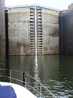
 We left Aqua Marina this morning. We went through:  Whitten Lock ( the big one at an 84' drop ) Montgomery Lock ( 33') Rankin Lock ( 31' ) Fulton Lock ( 26') Travel 74 miles today to a lovely anchorage at Smithville.

A GREAT DAY IN MUSCLE SHOALS ETC.

Image
 So we are spending 3 days in Aqua Marina in Iuka, MS - this is where the three states converge - can't tell if we are in MS, AL or TN. We rented a car and went to the site of the Shiloh Battlefield.......Shiloh, TN. Where was I in History class cause I seriously did not know about Shiloh. During the Civil War, April 6-7, 1862, the bloodiest battle that only lasted 2 days and produced more than 23,000 casualties. This park was transferred to the National Park Service in 1933 - 4200 acres.  This site is spectacular. They have all the sites marked of the different battles - depending on if you were from the North or from the South. If you are a history buff, this is a must see. Inked Mermaid and Talisman State of IOWA Memorial - Spectacular State of ILLINOIS Memorial - not as spectacular Shiloh is also a national cemetery. 3500 Civil War dead - 2300 are unknown soldiers CHAMPY'S FAMOUS FRIED CHICKEN W e had lunch at Champy's Famous Fried Chicken in Muscle Shoals, AL.  Doug ac